Calgary, Alberta–(Newsfile Corp. – February 19, 2026) – Legacy Gold Mines Ltd. (TSXV: LEGY) (the “Company” or “Legacy Gold“) is pleased to report assay results from the final four (4) Reverse Circulation (RC) drill holes from its 2025 surface exploration program on the Baner Gold Mine Property (the “Property“), in Idaho County, Idaho, USA, which is optioned by the Company. The latest results returned multiple intersections targeting the northern portion of the previously drilled Main Zone on the Property (see Figures below).
“Of the 16 R/C holes drilled last year, 12 returned notable widths of gold mineralization, and we are still awaiting the final set of assays,” said Brian Hinchcliffe, Legacy Gold’s CEO. “The Baner property is located in Idaho’s Orogrande mining district, and Legacy Gold’s 2026 drill campaign will continue to confirm and expand upon the previous drilling carried out by Champion Electric, from whom we have optioned the Property.”
“Legacy Gold has achieved all of its original goals for the 2025 drill program,” said Mike Sutton, Legacy Gold’s Vice President, Exploration. “We’ve intersected very wide zones such as 0.50 g/t Au over 108.2m (355ft), high-grade zones such as 6.7 g/t Au over 4.6m (15ft) within 1.2 g/t Au over 39.6m (130ft), expanded the gold system in multiple directions, identified strong evidence supporting the new interpretation of flatter dips, proved continuity of high-grade mineralization, and even intersected wide zones perpendicular to the main trend (at Baner Mine proper). The deposit is open in every direction.”
Highlights of Drilling:
- LG25-010 intersected 1.2 g/t Au over 39.6m (130ft) including 6.7 g/t Au over 4.6m (15ft) (with no sampling before a 1.2 g/t Au over 1.5m (5ft)); plus 0.74 g/t Au over 21.3m (70ft) including 2.4 g/t Au over 7.6m (25ft); plus 0.46 g/t Au over 13.7m (45ft) including 0 g/t Au over 6.1m (20ft) and including 1.45 g/t Au over 1.5m (5ft); hole LG25-010 zones are open to the east.
- LG25-006 intersected 0.66 g/t Au over 12.2m (40ft) including 1.4 g/t Au over 1.5m (5ft); plus 0.25 g/t Au over 15.2m (50ft) including 0.78 g/t Au over 1.5m (5ft).
- LG25-016 intersected 1.45 g/t Au over 13.7m (45ft), including 3.7 g/t Au over 1.5m (5ft); plus 5.26 g/t Au over 3.0m (10ft); plus 0.44 g/t Au over 13.7m (45ft).
- LG25-014 intersected 0.23 g/t Au over 10.7m (35ft).
- With infill assays, LG25-004 intersected 0.59 g/t Au over 71.6m (235ft)*, including 1.83 g/t Au over 1.5m (5ft) and 1.22 g/t Au over 1.5m (5ft), plus 0.71 g/t Au over 42.7m (140ft),** including 2.4 g/t Au over 7.6m (25ft)
- With infill assays, LG25-001 intersected 0.56 g/t Au over 39.6m (130ft),** plus 0.31 g/t Au over 41.1m (135ft).**
- With infill assays, LG25-002 intersected 0.50 g/t Au over 108.2m (355ft),** including 1.30 g/t Au over 9.1m (30ft), and 1.5 g/t Au over 1.5m (5ft) and 1.1 g/t Au over 1.5m (5ft) and 1.3 g/t Au over 1.5m (5ft); plus 0.47 g/t Au over 6.1m (20ft),* and ended in mineralization at a vertical depth of 120m (see Legacy Gold’s press release dated October 16, 2025)
- See Assay Results table below for additional intercepts. See also Figures 1-5.
Notes:
* previously released.
** infill sampling has changed previously released intersection.
High Grade and Continuity of High Grades
High grades have been intersected in many 2025 holes, including assays of 13.0 g/t Au over 1.5m (5ft) in hole LG25-003, 11.3 g/t Au over 1.5m (5ft) in hole LG25-010, and 10.0 g/t Au over 1.5m (5ft) in hole LG25-016.
Hole LG25-016, with a previously reported 6.0 g/t Au over 1.5m (5ft) (within 4.6 g/t Au over 3.0m (10ft) which is within 1.18 g/t Au over 24.4m (80ft)), is located 20m southeast of and below an intersection of LG25-010’s intersection of 11.3 g/t Au over 1.5m (5ft) within 6.7 g/t Au over 4.6m (15ft) which is within 1.2 g/t Au over 39.6m (130ft) and 20m southeast of and below an intersection (from previous operators) of 16.3 g/t Au over 0.3m (1.0ft) within 4.8 g/t Au over 5.9m (19.4ft) from hole ICG2018-16 (drilled by Idaho Champion, see Technical Report (defined below) for additional information). The hole LG25-010 and ICG2018-16 high-grade intersections are 3.0m apart and both are 20m up-dip at the same elevation as the 6.0 g/t Au over 1.5m. The 3 intersections show very good correlation, and continuity.
Using RC necessitates taking far bigger samples than the previous drilling with core (generally 5ft vs. 1.0ft/1.5ft), so obviously not as many high grades would be forthcoming. The previous core drilling returned 37 assays greater than 5.0 g/t Au.
Expansion of the Gold System in Multiple Directions
Legacy Gold undertook a 50m line soil survey that dove-tailed with the previous 200m line survey. It targeted high-grade gold anomalies along structural trends. Hole LG25-006 has intersected 0.66 g/t Au over 12.2m (40ft) at 136m northwest of the closest drilling. A soil anomaly extends more than 2,000m further northwest along the drilled trend and is co-incident with a similar magnetic anomaly to the Main Zone plus a strong I.P. conductor. This has big implications for the gold endowment of the Property if mineralization persists through this area because the 800m of consistently-mineralized drilled zones could continue for another 2,000m in that one direction (and more in several other directions). See Figure 6.
Holes LG25-016 and LG25-014 intersected 5.26 g/t Au over 3.0m (10ft) and 0.23 g/t Au over 10.7m (35ft) near surface at 164m up-hill from the closest drilling intercept. Surface gold soils are anomalous to here and at least another 163m up-dip. Hole LG25-016 also intersected 1.45 g/t Au over 13.7m (45ft) at 68m up-dip of the closest intersection, an intersection (from previous operators) of 8.7 g/t Au over 6.3m (20.7ft), including 146.7 g/t Au over 0.3m (1ft) from hole ICG2018-18. These intersections prove that there is mineralization, in a likely flat-dipping system, running all the way up the hill.
There exists a big soil anomaly in the SW of the Property which looks larger than the Main Zone soil anomaly; it has never been drilled but considerable placer gold was dredged with a ship from Crooked Creek abutting its east side.
The gold system is open in all directions.
Wide Zones
Three of the four main drilled areas have intersected very wide lower-grade intersections to the south such as 0.59 g/t Au over 71.6m (235ft) in hole LG25-004; 0.50 g/t Au over 108.2m (355ft) in hole LG25-002; and 0.32 g/t Au over 88.4m (290ft) in hole LG25-005 (see the Company’s November 17, 2025 press release plus infill new intersections in this press release). The total width of mineralization in holes to date include 235ft in hole LG25-001, plus 123m (405ft) in hole LG25-002, plus 75m (245ft) in hole LG25-003, plus 145m (475ft) in hole LG25-004 and 117m (385ft) in hole LG25-005. Importantly, the waste to mineralization appears to be far less than 1:1 (e.g. 0.26:1 in hole LG25-005).
New Interpretation Correct – Strong Evidence
The 2025 Baner Drill Program focused on testing for continuity of high-grade and wide low-grade zones of gold mineralization with a new flatter, east dipping interpretation of zones. This new interpretation is reflective of all the other deposits in the area, as opposed to the vertical dip assumed by previous operators, where mineralization is controlled by major structures that acted as conduits for gold-bearing fluids. This would result in better continuity of mineralization, a far greater potential resource, and the strip ratio in a production scenario would be greatly decreased. Intersections have been returned at expected locations in keeping with the interpretation.
Wide Zones Perpendicular to the Main Trend (at Baner Mine proper)
Intersections are along one of the 3 mineralization systems on the Property. A textbook shear system is interpreted to be present, similar to many deposits worldwide. There are 3 main orientations to zones – steep north-south along the main structures, flat dipping east-dipping riedel shear-related mineralization (like the Main Zone), and east-west veins (like the Baner vein system). We’ll find out which of the orientations holes LG25-001 and LG25-002 are, once follow-up diamond drilling takes place. The results from holes LG25-001 and LG25-002 (to date, LG25-001: 0.56 g/t Au over 39.6m (130ft), plus 0.31 g/t Au over 41.1m (135ft); and LG25-002: 0.50 g/t Au over 108.2m (355ft), plus 0.47 g/t Au over 6.1m (20ft) plus several other zones) are likely along the east-west mineralized system surrounding the Baner Veins where numerous adits and shafts are located along 3,000ft horizontal length. Holes LG25-001 and LG25-002 were expected to only return narrow, higher-grade intercepts similar to what was mined, but very wide intersections were returned.
Infill Assays
The Company approached this 2025 drill program with financial prudency and made the decision to initially only sample sections where there were quartz veining or low sulphides. Given the results to date, the Company has opted to sample all sections of all the holes drilled in this 2025 drill campaign and the assay results will be published upon receipt.
Initial assays from additional samples, not originally visibly, but thought to be as mineralized as the rest have returned significant grades such as:
- LG25-002: 0.31 g/t Au over 7.6m (25ft) plus 0.27 g/t Au over 6.1m (20ft), requires additional infill.
- LG25-004: 0.37 g/t Au over 24.4m (80ft) – still open – 0.75 g/t Au over 1.5m (5ft).
- LG25-007: 0.56 g/t Au over 4.6m (15ft).
- LG25-001: 0.21 g/t Au over 7.6m (25ft), requires additional infill for all zones.
Individual g/t Au assays at the start or end of intersections that are open (no assay back yet for next sample) include (all 1.5m (5ft) samples): 3.7, 1.5, 1.3, 1.2, 0.9, 0.75, 0.66, 0.65, 0.53, 0.5, 0.5, and 15 others greater than 0.2 and less than 0.5.
Discussion of Results
LG25-010 was designed to twin hole ICG2018-16 which had intersections of (in order down-hole):
- 0.46 g/t Au over 12.0m (39.4ft);
- 0.6 g/t Au over 12.5m (41.0ft), including 1.65 g/t Au over 2m (6ft);
- 3.7 g/t Au over 5.3m (17.4ft), including 18.8 g/t Au over 1.0m (0.3ft);
- 1.5 g/t Au over 10.2m (33.5ft), including 9.7 g/t Au over 0.5m (1.6ft), 9.4 g/t Au over 0.6m (2ft), 7.8 g/t Au over 0.5m (1.6ft); and
- 4.8 g/t Au over 5.9m (19.4ft), including 16.3 g/t Au over 0.3m (1.0ft).
Hole LG25-010 intersected 1.2 g/t Au over 39.6m (130ft) including 6.7 g/t Au over 4.6m (15ft) plus 0.74 g/t Au over 18.3m (60ft) plus 0.46 g/t Au over 13.7m (45ft). The 6.7 g/t Au over 4.6m (15ft) corresponds to the 4.8 g/t over 5.9m and is ~3m NE of it at the same elevation. Both correlate with previously-released 4.6 g/t Au over 3.0m at 20m down-dip and SE in hole LG25-012 (1.18 g/t Au over 24.4m (80ft), including 4.64 g/t Au over 3.0m (10ft) which includes 6.0 g/t Au over 1.5m (5ft), and including 4.9 g/t Au over 1.5m (5ft)). Continuity of high-grade mineralization is very good. The 0.74 g/t Au over 21.3m (70ft) correlates with the 0.6 g/t Au over 12.5m (41ft). The other 2 zones are awaiting assays.
LG25-016 was designed to see if mineralization is present up-hill and with a shallow east dip from an intersection of 8.7 g/t Au over 6.3m (20.7ft), including 146.7 g/t Au over 0.3m (1ft) from hole ICG2018-181. It successfully proves both with three separate zones intersected of 1.45 g/t Au over 13.7m (45ft), plus 5.26 g/t Au over 3.0m (10ft) plus 0.44 g/t Au over 13.7m (45ft). Hole LG25-016 also was designed to intersect a wide highly oxidized zone visible at the end of hole 14 but was stopped short of that target.
LG25-015 was designed to intersect a vertical structure trenched on surface at the collar of hole 7. The hole could not be completed to that depth with the RC rig. It is thought the hole drilled parallel to mineralization on either side but in a waste gap.
LG25-014 was a steep sub-vertical hole designed to intersect any flat-dipping zones as far west as possible. It intersected 0.23 g/t Au over 10.7m (35ft), and this represents the furthest west mineralization has been encountered by drilling. Assays are awaited for a very oxidized wide zone at the end of the hole. The 0.23 g/t Au over 10.7m (35ft) and the 5.22 g/t Au over 3.0m (10ft) in hole LG25-016 suggest a west or southwest dip to that zone which is opposite to the rest of the intersections that suggest an east dip- this could mean folding is present.
Note 1: These intercepts were drilled by Idaho Champion Gold, see Technical Report (defined below) for additional information.
Table 1: 2025 Baner Drill Program – Assay Results
| Hole ID | From | To | Intercept | From | To | Intercept | Au |
| (m) | (m) | (m) | (ft) | (ft) | (ft) | (g/t) | |
| LG25-006 | 0.0 | 15.2 | 15.2 | 0 | 50 | 50 | 0.25 |
| including | 0.0 | 1.5 | 1.5 | 0 | 5 | 5 | 0.78 |
| 15.2 | 51.8 | 36.6 | 50 | 170 | 120 | NS | |
| 51.8 | 64.0 | 12.2 | 170 | 210 | 40 | 0.66 | |
| including | 53.3 | 54.9 | 1.5 | 175 | 180 | 5 | 1.4 |
| 68.6 | 70.1 | 1.5 | 225 | 230 | 5 | 0.27 | |
| 70.1 | 79.2 | 9.1 | 230 | 260 | 30 | NS | |
| 93.0 | 129.5 | 36.6 | 305 | 425 | 120 | NS | |
| 134.1 | 155.4 | 21.3 | 440 | 510 | 70 | NS | |
| 160.0 | 185.9 | 25.9 | 525 | 610 | 85 | NS | |
| 193.5 | 214.9 | 21.3 | 635 | 705 | 70 | NS | |
| LG25-010 | 0.0 | 9.1 | 9.1 | 0 | 30 | 30 | NS |
| 19.8 | 35.1 | 15.2 | 65 | 115 | 50 | NS | |
| 36.6 | 50.3 | 13.7 | 120 | 165 | 45 | 0.46 | |
| including | 38.1 | 39.6 | 1.5 | 125 | 130 | 5 | 1.45 |
| including | 41.1 | 47.2 | 6.1 | 135 | 155 | 20 | NS |
| 48.8 | 50.3 | 1.5 | 160 | 165 | 5 | 1.05 | |
| 57.9 | 73.2 | 15.2 | 190 | 240 | 50 | NS | |
| 76.2 | 94.5 | 18.3 | 250 | 310 | 60 | 0.74 | |
| including | 77.7 | 79.2 | 1.5 | 255 | 260 | 5 | 1.8 |
| including | 86.9 | 88.4 | 1.5 | 285 | 290 | 5 | 1.7 |
| 96.0 | 108.2 | 12.2 | 315 | 355 | 40 | NS | |
| 112.8 | 118.9 | 6.1 | 370 | 390 | 20 | NS | |
| 118.9 | 158.5 | 39.6 | 390 | 520 | 130 | 1.18 | |
| including | 128.0 | 132.6 | 4.6 | 420 | 435 | 15 | 6.7 |
| including | 131.1 | 132.6 | 1.5 | 430 | 435 | 5 | 11.3 |
| LG25-016 | 0.0 | 7.6 | 7.6 | 0 | 25 | 25 | NS |
| 7.6 | 10.7 | 3.0 | 25 | 35 | 10 | 5.22 | |
| including | 9.1 | 10.7 | 1.5 | 30 | 35 | 5 | 9.93 |
| 13.7 | 15.2 | 1.5 | 45 | 50 | 5 | 0.23 | |
| 15.2 | 42.7 | 27.4 | 50 | 140 | 90 | NS | |
| 53.3 | 109.7 | 56.4 | 175 | 360 | 185 | NS | |
| 115.8 | 129.5 | 13.7 | 380 | 425 | 45 | 1.45 | |
| including | 126.5 | 128.0 | 1.5 | 415 | 420 | 5 | 3.71 |
| 134.1 | 157.0 | 22.9 | 440 | 515 | 75 | NS | |
| 157.0 | 170.7 | 13.7 | 515 | 560 | 45 | 0.44 | |
| 170.7 | 192.0 | 21.3 | 560 | 630 | 70 | NS | |
| 198.1 | 201.2 | 3.0 | 650 | 660 | 10 | 0.24 | |
| LG25-015 | 0.0 | 6.1 | 6.1 | 0 | 20 | 20 | NS |
| 10.7 | 16.8 | 6.1 | 35 | 55 | 20 | NS | |
| 21.3 | 47.2 | 25.9 | 70 | 155 | 85 | NS | |
| 51.8 | 56.4 | 4.6 | 170 | 185 | 15 | NS | |
| 64.0 | 70.1 | 6.1 | 210 | 230 | 20 | NS | |
| 106.7 | 108.2 | 1.5 | 350 | 355 | 5 | 0.3 | |
| 108.2 | 141.7 | 33.5 | 355 | 465 | 110 | NS | |
| 150.9 | 166.1 | 15.2 | 495 | 545 | 50 | NS | |
| 192.0 | 195.1 | 3.0 | 630 | 640 | 10 | 0.7 | |
| 201.2 | 202.7 | 1.5 | 660 | 665 | 5 | 0.21 | |
| LG25-014 | 0.0 | 7.6 | 7.6 | 0 | 25 | 25 | NS |
| 10.7 | 21.3 | 10.7 | 35 | 70 | 35 | 0.225 | |
| including | 13.7 | 15.2 | 1.5 | 45 | 50 | 5 | 0.48 |
| 29.0 | 30.5 | 1.5 | 95 | 100 | 5 | 0.2 | |
| 56.4 | 71.6 | 15.2 | 185 | 235 | 50 | NS | |
| including | 123.4 | 128.0 | 4.6 | 405 | 420 | 15 | NS |
| 134.1 | 143.3 | 9.1 | 440 | 470 | 30 | NS | |
| 157.0 | 158.5 | 1.5 | 515 | 520 | 5 | 0.3 | |
| 163.1 | 164.6 | 1.5 | 535 | 540 | 5 | 0.91 | |
| 169.2 | 178.3 | 9.1 | 555 | 585 | 30 | NS | |
| 221.0 | 233.2 | 12.2 | 725 | 765 | 40 | NS |
Notes: NS= not sampled; Composite intersections are calculated using a 0.2 g/t cutoff for gold with 10m internal dilution. True widths are unknown until zone dips are proven. Only visually altered samples were sent for assay; assaying was only for gold.
Table 2: 2025 Baner Drill Program – Infill Assay Results
| Hole ID | From | To | Intercept | From | To | Intercept | Au |
| (m) | (m) | (m) | (ft) | (ft) | (ft) | (g/t) | |
| LG25-004 | 3 | 4.6 | 1.6 | 10 | 15 | 5 | 0.26 |
| 6.1 | 9.1 | 3 | 20 | 30 | 10 | NS | |
| 15.2 | 57.9 | 42.7 | 50 | 190 | 140 | *0.71 | |
| incl. | 25.9 | 33.5 | 7.6 | 85 | 110 | 25 | *2.4 |
| incl. | 27.4 | 29 | 1.6 | 90 | 95 | 5 | 4.39 |
| 57.9 | 129.5 | 71.6 | 190 | 425 | 235 | *NS | |
| 131.1 | 202.7 | 71.6 | 430 | 665 | 235 | 0.59 | |
| incl. | 172.2 | 173.7 | 1.5 | 565 | 570 | 5 | 1.83 |
| incl. | 178.3 | 179.8 | 1.5 | 585 | 590 | 5 | 1.22 |
| LG25-007 | 0 | 3.1 | 3.1 | 0 | 10 | 10 | NS |
| 4.6 | 6.1 | 1.5 | 15 | 20 | 5 | 0.29 | |
| 9.1 | 10.7 | 1.6 | 30 | 35 | 5 | 0.2 | |
| 15.2 | 16.8 | 1.6 | 50 | 55 | 5 | 0.27 | |
| 22.9 | 24.4 | 1.5 | 75 | 80 | 5 | 1.25 | |
| 35.1 | 36.6 | 1.5 | 115 | 120 | 5 | 0.23 | |
| 41.1 | 44.2 | 3.1 | 135 | 145 | 10 | 0.29 | |
| 50.3 | 56.4 | 6.1 | 165 | 185 | 20 | *1.1 | |
| incl. | 50.3 | 51.8 | 1.5 | 165 | 170 | 5 | 2.7 |
| 67.1 | 68.6 | 1.5 | 220 | 225 | 5 | 0.49 | |
| 76.2 | 99.1 | 22.9 | 250 | 325 | 75 | NS | |
| 99.1 | 100.6 | 1.5 | 325 | 330 | 5 | 0.4 | |
| 103.6 | 109.7 | 6.1 | 340 | 360 | 20 | NS | |
| 109.7 | 112.8 | 3.1 | 360 | 370 | 10 | 1.16 | |
| 114.3 | 129.5 | 15.2 | 375 | 425 | 50 | NS | |
| 131.1 | 132.6 | 1.5 | 430 | 435 | 5 | 0.59 | |
| 135.6 | 137.2 | 1.6 | 445 | 450 | 5 | 0.2 | |
| 138.7 | 143.3 | 4.6 | 455 | 470 | 15 | NS | |
| 147.8 | 153.9 | 6.1 | 485 | 505 | 20 | 0.23 | |
| 157 | 158.5 | 1.5 | 515 | 520 | 5 | 0.22 | |
| 160 | 163.1 | 3.1 | 525 | 535 | 10 | 0.37 | |
| 175.3 | 181.4 | 6.1 | 575 | 595 | 20 | NS | |
| LG25-001 | 0 | 12.2 | 12.2 | 0 | 40 | 40 | NS |
| 13.7 | 16.8 | 3 | 45 | 55 | 10 | 0.18 | |
| 18.3 | 96.0 | 77.7 | 60 | 315 | 255 | NS | |
| 96.0 | 135.6 | 39.6 | 315 | 445 | 130 | *0.56 | |
| incl. | 102.1 | 108.2 | 6.1 | 335 | 355 | 20 | *NS |
| incl. | 109.7 | 115.8 | 6.1 | 360 | 380 | 20 | *2.1 |
| 137.2 | 143.3 | 6.1 | 450 | 470 | 20 | NS | |
| 153.9 | 155.4 | 1.5 | 505 | 510 | 5 | 0.2 | |
| 155.4 | 163.1 | 7.6 | 510 | 535 | 25 | NS | |
| 166.1 | 167.6 | 1.5 | 545 | 550 | 5 | 0.35 | |
| 172.2 | 213.4 | 41.1 | 565 | 700 | 135 | *0.31 | |
| incl. | 182.9 | 187.5 | 4.6 | 600 | 615 | 15 | NS |
| LG25-002 | 0 | 80.8 | 80.8 | 0 | 265 | 265 | NS |
| 91.4 | 97.5 | 6.1 | 300 | 320 | 20 | 0.47 | |
| 106.7 | 120.4 | 13.7 | 350 | 395 | 45 | NS | |
| 129.5 | 132.6 | 3 | 425 | 435 | 10 | 0.37 | |
| 149.4 | 257.6 | 108.2 | 490 | 845 | 355 | *0.50 | |
| incl. | 152.4 | 158.5 | 6.1 | 500 | 520 | 20 | NS |
| incl. | 158.5 | 160.0 | 1.5 | 520 | 525 | 5 | *1.5 |
| incl. | 164.6 | 166.1 | 1.5 | 540 | 545 | 5 | *1.1 |
| incl. | 190.5 | 207.3 | 16.8 | 625 | 680 | 55 | 1 |
| incl. | 193.5 | 202.7 | 9.1 | 635 | 665 | 30 | *1.3 |
| incl. | 236.2 | 237.7 | 1.5 | 775 | 780 | 5 | 1.33 |
Notes: NS= not sampled; Composite intersections are calculated using a 0.2 g/t cutoff for gold with 10m internal dilution. True widths are unknown until zone dips are proven. Only visually altered samples were sent for assay; assaying was only for gold. *New (the rest previously released)
Table 3: Drill Hole Coordinates
| Hole ID | Azimuth | Dip | Northing | Easting | Total Depth (m) |
Total Depth (ft) |
| LG25-006 | 299 | -45 | 5069887 | 615257 | 214.9 | 705 |
| LG25-010 | 234 | -85 | 5069806 | 615344 | 160.0 | 525 |
| LG25-014 | 162 | -77 | 5069816 | 615182 | 236.2 | 775 |
| LG25-015 | 92 | -45 | 5069816 | 615182 | 202.7 | 665 |
| LG25-016 | 107 | -70 | 5069816 | 615182 | 202.7 | 665 |
| LG25-001 | 221 | -45 | 5069285 | 615400 | 221.0 | 725 |
| LG25-002 | 185 | -45 | 5069278 | 615404 | 257.0 | 845 |
| LG25-004 | 252 | -60 | 5069487 | 615384 | 202.7 | 665 |
| LG25-007 | 234 | -85 | 5069820 | 615378 | 181.35 | 595 |
Geology and Mineralization
The belt of mineralization that traces through the Elk City and Orogrande mining districts is known as the Orogrande Shear Zone, and is estimated to be between 100-200m wide, with a general NNE trend. Gold mineralization occurs along this zone in numerous prospects and small historic mines. Most of the mineralization appears to be along Riedel shear structures that cross over between two bounding major north-south structures along the Orogrande Shear Zone. In general, higher grade historical mining was undertaken on narrow zones of strong sericite-silica-carbonate alteration and quartz veins. Intrusion-related structurally controlled mineralization has been suggested previously. At the Property, the predominant host rock is quartzite, with some biotite gneiss also present.
Review by Qualified Person
Mr. Mike Sutton, P.Geo., Director and VP of Exploration of the Company, is the Qualified Person, as defined under National Instrument 43-101 – Standards of Disclosure for Mineral Projects, who reviewed and approved scientific and technical disclosure in this press release. The Qualified Person has not reviewed the mineral tenure, nor independently verified the legal status and ownership of the Property or any underlying property agreements.
Drilling and Sampling: Drilling was carried out using a Foremost-built tracked MPD1500 RC drilling unit, the rig has jacks and a blade and is capable of working on small pads on steep ground to minimize ground prep. Drilling to final hole depth was completed using 4-inch pipe and a 5 1/4 inch bit. Holes were cased down to approximately 7.6m (25ft) with 8-inch steel casing drifted-in using a tricone bit. RC drilling uses a hammer and at depth below groundwater level a tricone bit was sometimes used.
RC drilling was done wet, with water actively pumped down the hole, mixing with pulverised sample, and coming through the cyclone to an 8-compartment rotary fan wet splitter. Each compartment can be shut off giving control of the amount of split material. Rotary splitter was set up with 1:2 split, with the half split going into a calico bag housed in a bucket for an assay sample. The remainder of the sample falls to the ground and runs into the sump. Each assay sample is for a 1.52m (5ft) interval. The splitter and cyclone are flushed every 4 samples or upon noticing a change in color. Chips were collected from the splitter reject and put into chip trays for reference.
Bar-coded Calico bags are pre-labelled, and a corresponding sequential from-to depth is pre-recorded in a spreadsheet. Quality control samples are included in the numerical sequence with B, S, or D designations for blanks, standards, and duplicates. The drilling team is responsible for changing the bags and regular company supervision and cross-checks on sample numbers and intervals avoids sample mix-ups. Filled sample bags are laid on the ground in order so a visual check can be easily performed when collecting samples.
Samples are dispatched to the ALS Global prep-lab in Twin Falls, Idaho, USA with final gold assays completed in Reno, Nevada. The lab has ISO/IEC 17025 accreditation. All samples are assayed for gold by Fire Assay, with gravimetric finish. The Company’s QA/QC program includes the regular insertion of blanks and standards into the sample shipments. Duplicates were prepared on-site with a riffle splitter. Standards, blanks and duplicates are inserted at approximately one per 15 samples.
About Legacy Gold Mines Ltd.
The Company is a Canadian-based gold exploration and development company that is listed on the TSX Venture Exchange under the symbol “LEGY”. The Company holds an option to acquire a 100% undivided interest in and to the mineral claims comprising the Property located in Idaho County, Idaho, USA.
Additional information about the Company and the Property is available on SEDAR+ at www.sedarplus.ca under the Company’s profile, including a technical report titled “NI 43-101 Technical Report on the Baner Project, Idaho County, Idaho, USA”, dated effective August 1, 2024, prepared by Steven A. Osterberg, Ph.D., P.G. (the “Technical Report“).
For further information, please contact:
Legacy Gold Mines Ltd.
Brian Hinchcliffe, Executive Chairman and Chief Executive Officer
CAUTIONARY STATEMENT REGARDING FORWARD-LOOKING INFORMATION: This press release includes certain “forward-looking statements” under applicable Canadian securities legislation. Forward-looking statements include, but are not limited to, timing and completion of any exploration, drilling and work programs on the Property, estimates of mineralization from drilling, sampling and geophysical surveys, geological information projected from drilling and sampling results and the potential quantities and grades of the target zones, the potential for minerals and/or mineral resources and reserves, and statements regarding the plans, intentions, beliefs, and current expectations of the Property and the Company that may be described herein. Forward-looking statements consist of statements that are not purely historical, including any statements regarding beliefs, plans, expectations or intentions regarding the future. Such information can generally be identified by the use of forward-looking wording such as “may”, “expect”, “estimate”, “anticipate”, “intend”, “believe” and “continue” or the negative thereof or similar variations. Readers are cautioned not to place undue reliance on forward-looking statements, as there can be no assurance that the plans, intentions or expectations upon which they are based will occur.
By their nature, forward-looking statements involve numerous assumptions, known and unknown risks and uncertainties, both general and specific, that contribute to the possibility that the predictions, estimates, forecasts, projections and other forward-looking statements will not occur. These assumptions, risks and uncertainties include, among other things, the state of the economy in general and capital markets in particular, as well as those risk factors discussed in the Filing Statement of the Company dated effective September 19, 2024 or referred to in the Company’s annual Management’s Discussion and Analysis for the year ended December 31, 2024 and the period ended September 30, 2025 available at www.sedarplus.ca, many of which are beyond the control of the Company. Forward-looking statements contained in this press release are expressly qualified by this cautionary statement.
The forward-looking statements contained in this press release are made as of the date of this press release. Except as required by law, the Company disclaims any intention and assumes no obligation to update or revise any forward-looking statements, whether as a result of new information, future events or otherwise. Additionally, the Company undertakes no obligation to comment on the expectations of, or statements made by, third parties in respect of the matters discussed above.
Neither the TSX Venture Exchange nor its Regulation Service Provider (as that term is defined in the policies of the TSX Venture Exchange) accepts responsibility for the adequacy or accuracy of this release.
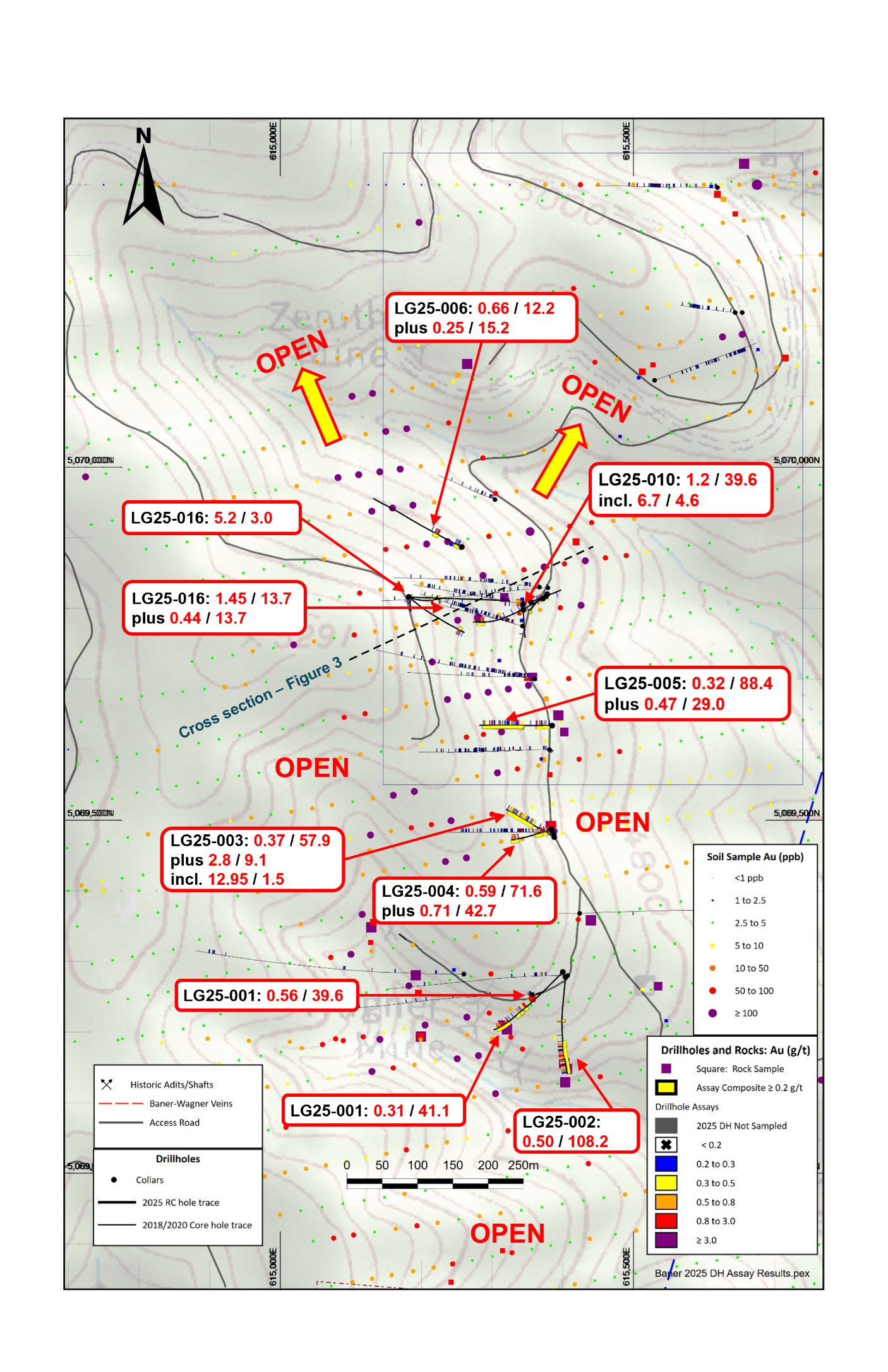
Figure 1: Plan View – 2025 Baner Drill Results
To view an enhanced version of this graphic, please visit:
https://images.newsfilecorp.com/files/10544/284489_0e42a931b47d4b0d_002full.jpg
Figure 2: Section View (Looking NW) – 2025 Baner Drill Results
To view an enhanced version of this graphic, please visit:
https://images.newsfilecorp.com/files/10544/284489_0e42a931b47d4b0d_003full.jpg
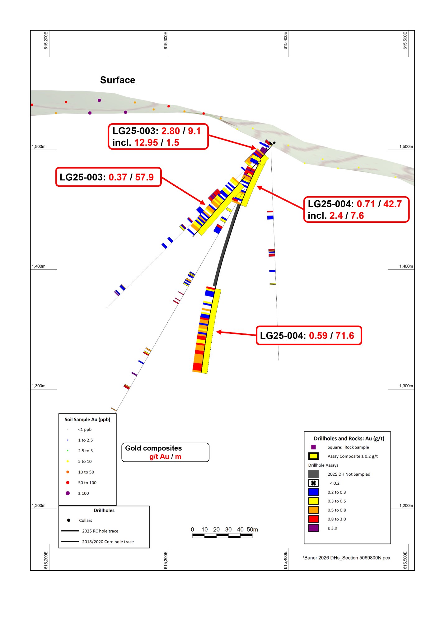
Figure 3: Cross Section (Looking North)- LG25-003 and LG25-004
To view an enhanced version of this graphic, please visit:
https://images.newsfilecorp.com/files/10544/284489_0e42a931b47d4b0d_004full.jpg
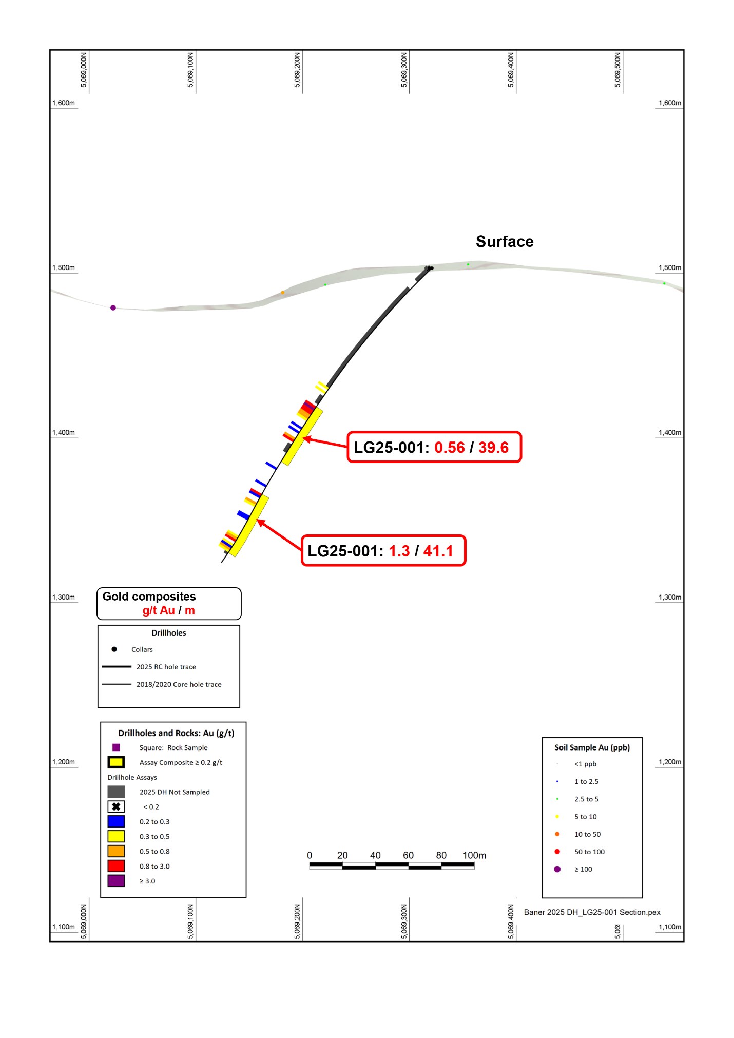
Figure 4: Cross Section (Looking West)- LG25-001
To view an enhanced version of this graphic, please visit:
https://images.newsfilecorp.com/files/10544/284489_0e42a931b47d4b0d_005full.jpg
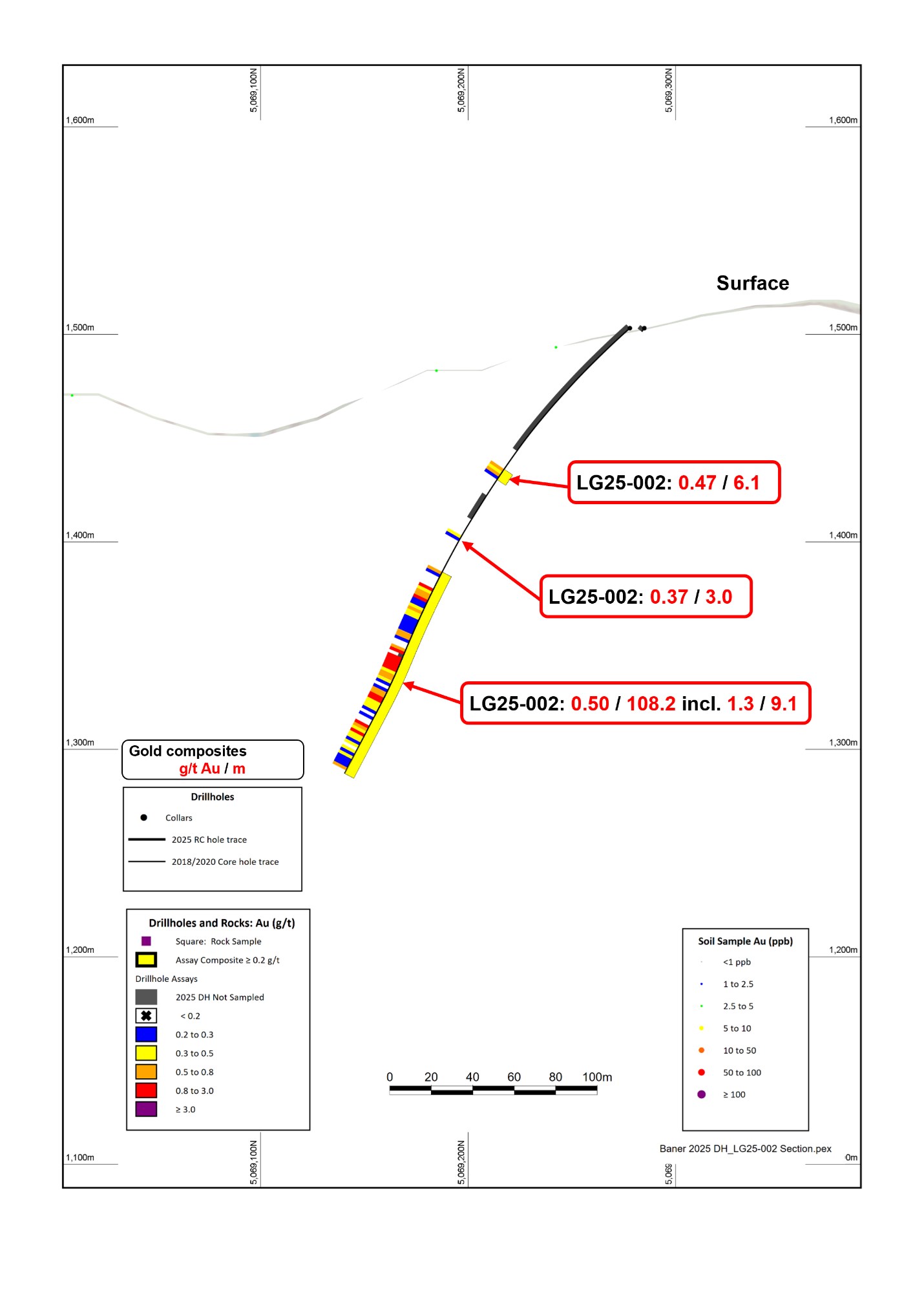
Figure 5: Cross Section (Looking West)- LG25-002
To view an enhanced version of this graphic, please visit:
https://images.newsfilecorp.com/files/10544/284489_0e42a931b47d4b0d_006full.jpg
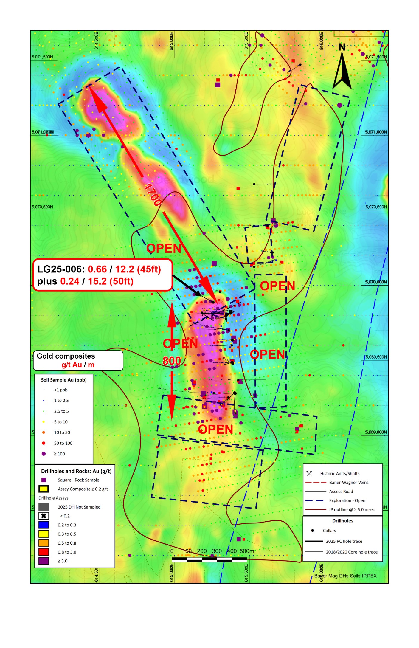
Figure 6: Plan View – Magnetics / Soils
To view an enhanced version of this graphic, please visit:
https://images.newsfilecorp.com/files/10544/284489_0e42a931b47d4b0d_007full.jpg
![]()
To view the source version of this press release, please visit https://www.newsfilecorp.com/release/284489
Source: Legacy Gold Mines Ltd.
Ready to Announce with Confidence?
Send us a message and a member of our TMX Newsfile team will contact you to discuss your needs.